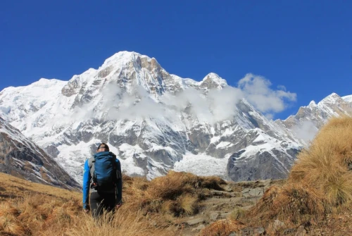
About Manaslu Circuit Trek
Trek Information | Details |
Duration | 12 Days |
Trekking Start | Machha Khola |
Ending Point | Dharapani |
Highest Point | Larkya La Pass – 5,106 m / 16,752 ft |
Mountain | Mount Manaslu – 8,163 m / 26,781 ft |
Difficulty | Strenuous / High-altitude |
Accommodation | Teahouses and mountain lodges |
Best Seasons | March–May and September–November |
Restricted Area | Yes |
Guide | Licensed trekking guide required |
Major River Valley | Budhi Gandaki |
12 Days Manaslu Circuit Trek Itinerary
Day 1: Drive from Kathmandu to Machha Khola
Distance: Approximately 160–170 km / 100–106 miles
Altitude: Machha Khola – 869 m / 2,851 ft
Driving time: Approximately 7–9 hours
Overnight: Machha Khola
Your Manaslu Circuit Trek itinerary from Kathmandu begins with an early morning scenic drive toward Machha Khola, the starting point of the trekking section.
The journey initially follows the Prithvi Highway before turning toward the Manaslu region. Along the way, you pass through Dhading Besi, continue toward Arughat, and follow the Budhi Gandaki River valley through Soti Khola before reaching Machha Khola.
The drive offers a fascinating transition from the busy Kathmandu Valley to Nepal's rural mountain landscape. You will see terraced farmland, traditional villages, forested hills, suspension bridges, waterfalls, and the Budhi Gandaki River along the route.
Road conditions can vary considerably depending on weather, traffic, construction, and seasonal conditions. During the monsoon and periods of road maintenance, the journey may take longer than the estimated 7–9 hours.
Machha Khola is the starting point of the walking section of the classic Manaslu Circuit Trek.
Day 2: Trek from Machha Khola to Jagat
Distance: Approximately 22 km / 13.7 miles
Altitude: Jagat – 1,340 m / 4,397 ft
Trekking time: Approximately 6–7 hours
Overnight: Jagat
The first trekking day of your Manaslu Circuit Trek follows the spectacular Budhi Gandaki River, taking you deeper into the remote Himalayan landscape. The trail passes through subtropical forests, rocky sections, waterfalls, suspension bridges, and traditional mountain settlements.
Leaving Machha Khola, you walk through Khorlabesi, a small riverside settlement, before continuing toward Tatopani, which is known for its natural hot springs. This is a pleasant place to take a short break and enjoy the warm water when conditions and time permit.
From Tatopani, the trail becomes more rugged as it follows the narrow Budhi Gandaki gorge. You cross several suspension bridges and pass through Dovan and Thulo Dunga, with dramatic cliffs and cascading waterfalls surrounding the trail.
The route gradually climbs through increasingly narrow sections of the valley before reaching Jagat, a beautiful traditional settlement with stone-paved streets. Jagat is also an important checkpoint where trekking permits are checked before continuing deeper into the Manaslu Conservation Area.
Day 3: Trek from Jagat to Deng
Distance: Approximately 19–20 km / 12–12.5 miles
Altitude: Deng – 1,860 m / 6,109 ft
Trekking time: Approximately 6–7 hours
Overnight: Deng
Leaving Jagat, the trail continues deeper into the Budhi Gandaki Valley, with the landscape becoming increasingly rugged and dramatic. Today's route combines forested trails, suspension bridges, steep river gorges, and traditional Himalayan settlements.
The trail first passes through Salleri and Sirdibas, where you begin to notice the distinctive Gurung culture and traditional mountain architecture. Continuing north, the route reaches Philim, one of the larger settlements along the Manaslu Circuit. Philim is surrounded by green hills, dramatic cliffs, and terraced farmland.
From Philim, the trail follows the Budhi Gandaki through a narrower gorge, crossing suspension bridges and passing impressive waterfalls. You then continue through Ekle Bhatti and toward Pewa, enjoying increasingly rugged mountain scenery before reaching Deng.
As you travel farther north, the cultural landscape gradually changes. Buddhist prayer flags, mani walls, chortens, and Tibetan-influenced architecture become increasingly common, signaling your approach toward the upper Manaslu and Nubri Valley.
Deng is a peaceful mountain settlement surrounded by forests and steep Himalayan slopes and provides your first strong sense that you are entering the remote high-altitude environment of the Manaslu region.
Day 4: Trek from Deng to Namrung
Distance: Approximately 19 km / 11.8 miles
Altitude: Namrung – 2,630 m / 8,629 ft
Trekking time: Approximately 6–7 hours
Overnight: Namrung
Today's trail takes you deeper into the Manaslu Himalayan region, following the Budhi Gandaki River through increasingly dramatic mountain scenery. As you gain altitude, the landscape gradually changes from dense lower-elevation forests to a cooler Himalayan environment dominated by pine, fir, and other mountain vegetation.
Leaving Deng, the trail passes through small settlements and forested sections before reaching Bihi and Bihi Phedi. Along the way, you cross suspension bridges and walk beneath towering cliffs while the Budhi Gandaki continues to carve its way through the valley.
The route then continues toward Ghap, a picturesque village surrounded by forests and steep mountain slopes. From Ghap, the trail climbs steadily toward Namrung, with several sections passing through beautiful forests and alongside cascading waterfalls.
As you approach Namrung, the scenery becomes increasingly spectacular. On clear days, you can enjoy impressive views of Manaslu, Himalchuli, and Sringi Himal.
Namrung also marks an important cultural transition on the trek. As you move farther into the upper Nubri Valley, Tibetan Buddhist influences become more prominent, with prayer flags, mani walls, chortens, and distinctive stone houses becoming increasingly common.
Day 5: Trek from Namrung to Lho
Distance: Approximately 11 km / 6.8 miles
Altitude: Lho – 3,180 m / 10,433 ft
Trekking time: Approximately 4–5 hours
Overnight: Lho
Today's trek takes you farther into the upper Nubri Valley, where the landscape becomes more alpine and the influence of Tibetan Buddhist culture becomes increasingly evident.
Leaving Namrung, the trail climbs gradually through beautiful forests and open mountain landscapes toward Lihi, a traditional Himalayan village surrounded by spectacular peaks. The route continues through Sho, another picturesque settlement where you can see traditional stone houses, mani walls, chortens, and colorful prayer flags.
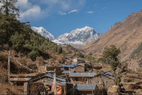
As you approach Lho, the views of the Manaslu range become increasingly impressive. The village sits in a beautiful mountain setting beneath towering Himalayan peaks and is considered one of the most scenic settlements on the Manaslu Circuit.
Lho is home to Ribung Gompa, an important Buddhist monastery located above the village. If time and conditions permit, visiting the monastery provides an excellent opportunity to experience the spiritual traditions and architecture of the upper Nubri Valley.
The combination of traditional villages, Buddhist heritage, and spectacular mountain scenery makes the Namrung-to-Lho section one of the most memorable short trekking days on the circuit.
Day 6: Trek from Lho to Samagaon
Distance: Approximately 15 km / 9.3 miles
Altitude: Samagaon – 3,530 m / 11,581 ft
Trekking time: Approximately 4–5 hours
Highlights: Lho – Lho Phedi – Syala – Pungyen Glacier viewpoint – Samagaon
Overnight: Samagaon
Today's relatively short trek takes you deeper into the high Himalayas of the Manaslu region, with spectacular mountain scenery throughout the journey. As you leave Lho, the trail gradually climbs through pine and alpine forests before opening into broader mountain landscapes.
One of the most scenic sections is Syala, a beautiful high-altitude village surrounded by an impressive panorama of Himalayan peaks. On clear days, you can enjoy views of Manaslu, Manaslu North, Himalchuli, and other surrounding peaks.
The trail continues through alpine meadows and glacial landscapes before reaching Samagaon, one of the most important settlements in the upper Nubri Valley. The village is surrounded by dramatic mountains and is an important cultural and logistical center for trekkers heading toward Manaslu Base Camp, Samdo, and Larkya La.
Samagaon is also a crucial acclimatization stop. The following day is reserved for acclimatization, allowing trekkers to adjust to the increasing altitude before continuing above 4,000 meters.
Day 7: Acclimatization Day at Samagaon
Altitude: 3,530 m / 11,581 ft
Hiking distance: Approximately 5–12 km / 3–7.5 miles, depending on the excursion
Hiking time: Approximately 3–7 hours, depending on the route
Overnight: Samagaon
A proper acclimatization day is an essential part of a safe and successful Manaslu Circuit Trek. At 3,530 meters, this additional day allows your body to adjust to the increasing altitude before continuing toward Samdo, Dharamsala, and the Larkya La Pass.
Rather than spending the entire day resting, trekkers can take a gradual day hike and return to Samagaon to sleep at the same altitude.
Pungyen Gompa
One of the most rewarding options is the hike to Pungyen Gompa, a remote Buddhist monastery situated above the Samagaon area. The route takes you through open yak pastures and dramatic mountain landscapes, with impressive views toward Mount Manaslu and the surrounding glaciers. It is a particularly good choice for trekkers looking for a combination of acclimatization, Himalayan scenery, and Buddhist culture.
Birendra Lake
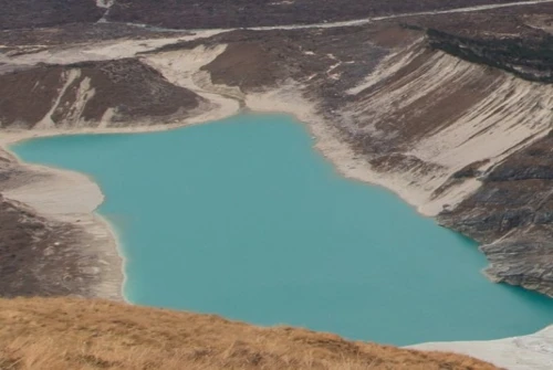
Another popular option is Birendra Lake, a beautiful glacial lake near Samagaon. The hike is shorter and less demanding than the Manaslu Base Camp excursion, making it suitable for trekkers who want a moderate acclimatization walk.
Manaslu Base Camp
For trekkers who are feeling strong and well acclimatized, the Manaslu Base Camp hike is the most ambitious option. The route climbs through increasingly rugged glacial terrain and provides spectacular views of the Manaslu massif. It is a demanding full-day excursion, so your guide should assess weather, trail conditions, and your physical condition before recommending it.
Sama Monastery and Samagaon Village
For a gentler cultural day, you can explore Samagaon village and its Buddhist heritage, including local monasteries, mani walls, chortens, prayer wheels, and traditional stone houses. This option allows trekkers to experience the culture of the upper Nubri Valley without undertaking a strenuous high-altitude hike.
Our recommendation: For a standard 12-day itinerary, Pungyen Gompa or Birendra Lake is a very good choice. If the group is fit, well acclimatized, and weather conditions are favorable, Manaslu Base Camp can be the highlight of the day.
Important: The goal is not simply to hike as high as possible. The excursion should help with acclimatization without leaving trekkers excessively exhausted before the higher-altitude section begins.
Day 8: Trek from Samagaon to Samdo
Distance: Approximately 8–9 km / 5–5.6 miles
Altitude: Samdo – 3,860 m / 12,660 ft
Trekking time: Approximately 3–4 hours
Overnight: Samdo
After your acclimatization day in Samagaon, today's relatively short trek takes you deeper into the high-altitude landscape of the Manaslu region. The trail gradually leaves the greener surroundings of Samagaon and enters a much drier and more rugged environment.
The route follows the upper Budhi Gandaki Valley, crossing open yak pastures and barren mountain terrain. As you gain elevation, vegetation becomes increasingly sparse, while the surrounding Himalayan peaks appear closer and more imposing.
Along the way, you can enjoy spectacular views toward Manaslu, Manaslu North, Nagdi Chuli, and the surrounding Himalayan ridges. The trail also provides an increasingly strong sense of the region's Tibetan cultural heritage, with prayer flags, mani walls, chortens, and traditional stone structures appearing along the route.
Eventually, the trail reaches Samdo, one of the highest permanent settlements on the Manaslu Circuit. Samdo is a traditional Tibetan-influenced village situated close to the Nepal–Tibet border and historically connected with Tibetan trade and pastoral life.
Because today's walking distance is relatively short, you normally arrive at Samdo with plenty of time to rest, explore the village, and further acclimatize before the trek climbs toward Dharamsala.
Altitude note: At nearly 3,900 meters, this is an important acclimatization stage. Walk slowly, stay well hydrated, and follow your guide's advice before continuing toward the higher elevations of Dharamsala and Larkya La.
Day 9: Trek from Samdo to Dharamsala
Distance: Approximately 11–12 km / 6.8–7.5 miles
Altitude: Dharamsala / Larkya La Phedi – 4,460 m / 14,632 ft
Trekking time: Approximately 4–5 hours
Overnight: Dharamsala / Larkya La Phedi
Today you leave Samdo and make a steady ascent toward Dharamsala, also known as Larkya La Phedi, the final overnight stop before crossing the spectacular Larkya La Pass.
The trail gradually climbs through a stark and increasingly barren high-altitude landscape. The green vegetation of the lower Manaslu region has now disappeared, replaced by rocky slopes, alpine meadows, glacial streams, and exposed mountain terrain.
Along the way, you pass through the historic Larkya Bazaar area, traditionally associated with trade between the Nepalese and Tibetan communities. As you approach Dharamsala, the views become increasingly dramatic, with surrounding peaks, glaciers, and rocky ridges creating an impressive Himalayan wilderness.
The final section is a gradual but noticeable climb toward Dharamsala, where the thin air and cold temperatures remind you that you are now at a serious altitude.
Preparing for Larkya La Pass
Dharamsala is a basic high-altitude overnight camp, and accommodation facilities are considerably more limited than in lower villages. Temperatures can drop well below freezing, particularly during the night and before the early-morning departure.
Because tomorrow is the most demanding day of the Manaslu Circuit Trek, trekkers should keep the evening relaxed, eat a nutritious dinner, prepare their backpack and warm clothing, and get to bed early.
The next morning typically begins very early, allowing sufficient time to cross Larkya La Pass (5,106 m / 16,752 ft) and descend toward Bhimtang.
Altitude note: At 4,460 meters, Dharamsala is one of the highest overnight points of the trek. Pay close attention to how you feel, stay hydrated, and immediately inform your guide if you experience significant altitude-related symptoms.
Day 10: Cross Larkya La Pass and Trek to Bhimtang
Distance: Approximately 18–20 km / 11–12.5 miles
Highest point: Larkya La Pass – 5,106 m / 16,752 ft
Trekking time: Approximately 8–10 hours
Overnight: Bhimtang
Day 10 is the major highlight of the Manaslu Circuit Trek. It is the longest and most demanding day of the journey, combining a high-altitude pass crossing with a spectacular descent into the greener landscapes around Bhimtang.
You normally begin before sunrise from Dharamsala/Larkya La Phedi. The early start allows enough time to cross Larkya La Pass and reach Bhimtang before late afternoon. The trail gradually climbs through a stark landscape of rocky slopes, glacial terrain, and snow-covered sections, depending on the season.
As you ascend, the air becomes noticeably thinner and the cold, wind, snow, and uneven terrain can make the climb physically demanding. Your pace should remain slow and steady, with regular short breaks as recommended by your guide.
Crossing Larkya La Pass
After several hours of climbing, you reach the Larkya La Pass at 5,106 meters (16,752 feet), the highest point of the classic Manaslu Circuit.
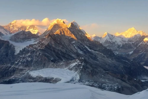
The summit is marked by prayer flags and traditional Buddhist symbols, creating a memorable Himalayan pass-crossing experience. On clear days, the panoramic views extend across spectacular peaks and high mountain ranges, including Himlung Himal, Cheo Himal, Kang Guru, and Annapurna II.
Take time to enjoy the views and celebrate the achievement, but avoid staying at the pass for too long because of the extreme altitude and changing mountain weather.
Descent to Bhimtang
From Larkya La, the trail begins a long and sometimes steep descent toward Bhimtang. The terrain gradually changes from rocky high-altitude slopes and glacial landscapes to alpine meadows and eventually beautiful Himalayan forests.
As you lose elevation, the air becomes warmer and vegetation returns. The dramatic contrast between the barren pass environment and the green landscapes around Bhimtang makes this descent particularly rewarding.
After many hours on the trail, you finally reach Bhimtang, a beautiful mountain settlement surrounded by forests and spectacular peaks. Arriving here after successfully crossing Larkya La is one of the most satisfying moments of the entire Manaslu Circuit..
Altitude & safety note: This is the most physically demanding day of the trek. Weather at Larkya La can change quickly, particularly with strong winds, snowfall, or poor visibility. Follow your guide's instructions, maintain a steady pace, stay hydrated, and be prepared for an early start.
Day 11: Trek from Bhimtang to Dharapani
Distance: Approximately 18 km / 11.2 miles
Altitude: Dharapani – 1,960 m / 6,430 ft
Trekking time: Approximately 6–7 hours
Overnight: Dharapani
After the challenging crossing of Larkya La Pass, today's trail descends significantly toward the lower valleys. The dramatic change in altitude brings a noticeable transformation in the landscape, from barren high-altitude terrain to lush forests, green hills, and warmer mountain villages.
Leaving Bhimtang, the trail passes through beautiful pine and rhododendron forests. The route gradually descends through Yak Kharka and toward Gho, where traditional stone houses and cultivated hillsides begin to appear more frequently.
The trail then continues toward Tilije, a picturesque settlement known for its traditional architecture and mountain culture. From Tilije, you cross the Dudh Khola and continue toward Thonje before eventually reaching the larger settlement of Dharapani.
As you approach Dharapani, you officially enter the Annapurna Conservation Area and connect with the famous Annapurna Circuit Trek route. This junction makes Dharapani an important transportation and trekking hub in the region.
For trekkers following the classic Manaslu Circuit Trek, Dharapani marks the completion of the main walking section. After nearly two weeks of trekking through remote valleys, Tibetan-influenced villages, glaciers, forests, and high mountain passes, reaching Dharapani provides a well-earned sense of accomplishment.
Route note: Dharapani is the point where the Manaslu Circuit connects with the Annapurna Circuit. Trekkers with additional time can continue toward destinations such as Chame, Pisang, Manang, and Thorong La, while those completing the 12-day Manaslu itinerary continue by road the following day.
Day 12: Drive from Dharapani to Kathmandu
Distance: Approximately 200–220 km / 124–137 miles by road
Kathmandu altitude: Approximately 1,400 m / 4,593 ft
Driving time: Approximately 8–10+ hours
Overnight: Kathmandu
After breakfast, you begin the final journey of your 12-day Manaslu Circuit Trek, driving from Dharapani toward Kathmandu.
The road initially follows the Marsyangdi River Valley, passing through scenic mountain settlements and deep river gorges. Depending on road conditions, the journey takes you through places such as Tal, Chamje, Jagat, and Besisahar before joining the main highway toward Kathmandu.
Besisahar is an important transportation hub and the traditional gateway to the Annapurna and Manaslu regions. From here, the road continues through Dumre and the Middle Hills before gradually returning to the Kathmandu Valley.
The scenery changes dramatically during the drive. The rugged Himalayan mountains and forests around Dharapani gradually give way to green hills, terraced farmland, busy market towns, and eventually the urban landscape of Kathmandu.
Road conditions can vary considerably, particularly during the monsoon season, road construction, or periods of heavy traffic. Therefore, the actual driving time may be longer than the estimated 8–10 hours.
Upon arrival in Kathmandu, your 12-day Manaslu Circuit Trek officially comes to an end. After completing the remote trails, traditional villages, high-altitude landscapes, and the spectacular Larkya La Pass, you can relax and celebrate the successful completion of your Himalayan adventure.
End of the Manaslu Circuit Trek
After 12 days of trekking and driving, you have completed one of Nepal's most spectacular Himalayan journeys from Machha Khola, through the remote Budhi Gandaki Valley, across Larkya La Pass (5,106 m), and down to Dharapani.
Why Is the Manaslu Circuit Trek So Popular?
The Manaslu Circuit Trek is one of Nepal’s most rewarding off-the-beaten-path trekking routes, combining spectacular Himalayan scenery, traditional villages, Tibetan Buddhist culture, and the challenging Larkya La Pass (5,106 m).
Its popularity comes from the incredible variety along the Manaslu Trek route from lush forests and the Budhi Gandaki Valley to glaciers, high-altitude landscapes, and panoramic views of Mount Manaslu (8,163 m).
Top Highlights of the Manaslu Circuit
Mount Manaslu (8,163 m) and spectacular Himalayan views
Larkya La Pass (5,106 m) – the trek’s major high-altitude challenge
Traditional Gurung and Tibetan-influenced villages
Ancient monasteries, gompas, chortens, and mani walls
Birendra Lake, glaciers, and dramatic river valleys
Diverse landscapes from subtropical forests to alpine terrain
Teahouse trekking through remote Himalayan communities
Connection with the Annapurna Circuit at Dharapani
The Manaslu Circuit Trek itinerary is ideal for trekkers looking for a combination of adventure, culture, wilderness, and high-altitude Himalayan scenery away from Nepal’s busiest trekking trails.
The Changing Manaslu Trekking Route
The Manaslu Circuit Trek route has changed significantly in recent years as road construction and transportation infrastructure have expanded through the lower Budhi Gandaki Valley.
Some sections that were once traveled entirely on foot now run alongside road networks, meaning trail conditions, walking distances, and daily trekking times can change from season to season.
For this reason, trekkers should always use an updated Manaslu Circuit Trek map and remain flexible with the itinerary. Your guide can adjust walking sections when necessary to avoid road stretches and select safer or more scenic alternative trails.
The upper Manaslu trekking route remains much more remote and spectacular, particularly around Namrung, Lho, Samagaon, Samdo, Dharamsala, and Larkya La Pass. This section offers the classic combination of high Himalayan scenery, Tibetan Buddhist culture, traditional villages, glaciers, and challenging mountain trails.
At All Nepal Hiking, we can customize your Manaslu Circuit Trek itinerary with suitable side trips and alternative trails based on current conditions, available time, fitness level, and your interests.
Best Side Trips on the Manaslu Circuit
One of the biggest advantages of the Manaslu Circuit Trek is the opportunity to explore hidden valleys, Buddhist monasteries, glacial lakes, and remote mountain viewpoints beyond the main trail. If you have extra days, these Manaslu side trips can make your journey more scenic, cultural, and rewarding.
Manaslu Base Camp
From Samagaon, the hike toward Manaslu Base Camp is one of the most spectacular optional excursions. The trail leads into rugged glacial terrain with impressive views of Mount Manaslu, glaciers, and surrounding Himalayan peaks. It is best suited to trekkers who are well acclimatized and prepared for a demanding day hike.
Birendra Lake
Birendra Lake is a beautiful glacial lake near Samagaon and one of the easiest popular side trips on the Manaslu Circuit route. Its relatively short hiking distance makes it an excellent option for an acclimatization day, while the surrounding views provide great opportunities for mountain photography.
Pungyen Gompa
Pungyen Gompa is a remote Buddhist monastery located above the Samagaon area. The excursion combines Tibetan Buddhist culture, mountain scenery, alpine landscapes, and acclimatization. For trekkers interested in both nature and local spirituality, Pungyen Gompa is one of the best additions to a Manaslu itinerary.
Rui La
From Samdo, experienced trekkers can consider an excursion toward Rui La, a historic high-altitude crossing near the Nepal–Tibet border. The hike involves significant elevation gain and should only be undertaken with adequate acclimatization, suitable weather, and guidance from a qualified local trekking team.
Kal Tal (Death Lake)
Kal Tal, also known as Kalchhuman Tal or Death Lake, is a remote high-altitude lake accessible from the Prok area. It can be included in a longer Manaslu itinerary and offers a quieter experience away from the main trekking route.
Serang & Nubri Valley Cultural Trails
Trekkers with additional time can explore Serang, Bhi, Prok, and other traditional Nubri Valley settlements. These extended routes provide opportunities to discover ancient monasteries, traditional villages, Buddhist culture, and landscapes that receive far fewer visitors than the main Manaslu Circuit.
Can You Combine Manaslu with the Annapurna Circuit?
Yes. The classic Manaslu Circuit Trek descends to Dharapani, where the trail connects with the famous Annapurna Circuit. This makes it possible for trekkers with additional time to continue into the Annapurna region rather than returning directly to Kathmandu.
After completing the Larkya La Pass, you can continue from Dharapani toward the Annapurna region and, depending on your itinerary, explore Nar Phu Valley, Tilicho Lake, Thorong La Pass, and Muktinath. Combining the Manaslu and Annapurna routes creates a much longer Himalayan adventure with diverse landscapes, traditional villages, Buddhist culture, glaciers, and multiple high-altitude environments.
A combined Manaslu Circuit and Annapurna Circuit Trek can take several weeks and requires careful planning for altitude, trekking distance, weather, accommodation, and acclimatization. It should not be considered a simple extension of the standard 12-day Manaslu Circuit Trek, as adding destinations such as Nar Phu Valley and Tilicho Lake can substantially increase the overall difficulty and duration.
For trekkers with enough time, however, combining Manaslu and Annapurna is an excellent way to experience two of Nepal's most spectacular trekking regions in one extended Himalayan journey.
How Many Days Do You Need for the Manaslu Trek?
The Manaslu Circuit Trek can be customized from around 7 to 18+ days, depending on your available time, trekking experience, acclimatization needs, and whether you want to include side trips.
7–9 Day Short Manaslu Trek
A 7- to 9-day Manaslu itinerary is possible only as a highly compressed option and is best suited to very fit, experienced trekkers. It leaves little flexibility for weather, trail conditions, or altitude adjustment.
For most trekkers, we recommend allowing more time rather than rushing the Manaslu Circuit Trek route, particularly because the itinerary includes the demanding Larkya La Pass at 5,106 m.
10-Day Manaslu Circuit
A 10-day Manaslu Circuit Trek can work for physically fit trekkers with previous high-altitude trekking experience and limited time. However, the shorter schedule means less flexibility and a faster progression to higher elevations.
12-Day Manaslu Circuit
The 12-day Manaslu Circuit Trek offers a practical balance between trekking time, acclimatization, and the classic route.
The itinerary includes a gradual ascent, an acclimatization day at Samagaon, preparation for Larkya La, the classic pass crossing, descent to Dharapani, and transportation back to Kathmandu.
For many international trekkers, 12 days is an excellent standard Manaslu Circuit itinerary.
14–18+ Day Manaslu Trek
If you have more time, a 14- to 18+ day Manaslu Trek allows you to experience the region in greater depth. Additional days can be used for Tsum Valley, Pungyen Gompa, Manaslu Base Camp, Birendra Lake, Rui La, cultural excursions, and extra acclimatization days.
A longer itinerary is particularly suitable for travelers who want to explore the Manaslu region rather than simply complete the circuit as quickly as possible.
At All Nepal Hiking, we can customize your Manaslu Trek from 7 to 18+ days according to your schedule, trekking experience, fitness level, and preferred side trips.
Manaslu Circuit Trek Difficulty
The Manaslu Circuit Trek is generally considered a strenuous high-altitude trek. It combines long trekking days, steep ascents and descents, rugged mountain trails, and the challenging crossing of Larkya La Pass at 5,106 m (16,752 ft).
Trekkers should be prepared for 5–8 hours of walking on most days, with some sections requiring longer days. The trail includes rocky and uneven terrain, suspension bridges, stone staircases, steep climbs, and changing weather conditions.
Altitude is one of the biggest challenges. The route gradually climbs from Machha Khola to more than 4,000 meters before reaching Larkya La, so proper acclimatization is essential. The scheduled acclimatization day at Samagaon (3,530 m) helps trekkers prepare for the higher sections.
The most demanding day is usually the journey from Dharamsala across Larkya La Pass to Bhimtang, which can take approximately 8–10 hours depending on weather, trail conditions, and individual pace.
Previous trekking experience is helpful, but the Manaslu Circuit does not require technical mountaineering skills. With proper preparation, gradual acclimatization, a suitable itinerary, and an experienced trekking guide, fit and well-prepared first-time high-altitude trekkers can also successfully complete the route.
Manaslu Circuit Trek Cost
The Manaslu Circuit Trek cost depends on several factors, including the number of trekkers, itinerary length, transportation, accommodation, permits, guide and porter services, meals, and optional side trips.
At All Nepal Hiking, we offer flexible packages so you can choose the services that best match your budget and trekking plans. The standard 12-day Manaslu Circuit Trek starts from US$895 per person .
Manaslu Circuit Trek Price
Group Size | Price Per Person |
1 person | US$1,085 |
2–6 people | US$895 |
7–10 people | US$785 |
11–20 people | US$749 |
Group discounts are available, making the Manaslu Circuit Trek more affordable for families, friends, and organized trekking groups.
The final price may vary depending on your preferred transportation, hotel category in Kathmandu, private or group trekking arrangements, porter services, and additional activities.
If you choose an extended itinerary such as Manaslu with Tsum Valley, Manaslu side trips, or a combined Manaslu and Annapurna Circuit Trek, the total cost will naturally be higher because of the additional trekking days, accommodation, meals, transportation, and permits.
Final Thoughts: Is the Manaslu Circuit Trek Right for You?
The Manaslu Circuit Trek is an exceptional Himalayan adventure that combines mountain scenery, wilderness, traditional villages, Buddhist culture, and high-altitude trekking in one unforgettable journey.
From the river valleys around Machha Khola to the Tibetan-influenced villages of the Nubri Valley, the spectacular surroundings of Samagaon, and the challenging Larkya La Pass (5,106 m), every stage of the trek offers a different experience.
For most trekkers, the 12-day Manaslu Circuit Trek itinerary provides an excellent balance between trekking, acclimatization, and time. Those with additional days can enrich the journey with Tsum Valley, Manaslu Base Camp, Birendra Lake, Pungyen Gompa, and other selected side trips.
Experienced trekkers with several weeks available can continue from Dharapani into the Annapurna region, creating a much longer Himalayan adventure.
The Manaslu Circuit should not simply be viewed as a race to reach Larkya La. The villages, monasteries, local communities, landscapes, mountain views, and changing environments are equally important parts of the experience.
Ready to explore Manaslu? Plan your journey with All Nepal Hiking Base and let our local trekking team create the right itinerary for your time, experience, fitness level, and Himalayan goals.
Frequently Asked Questions About Manaslu Trek Itinerary
How many days is the Manaslu Circuit Trek itinerary?
The standard Manaslu Circuit Trek itinerary takes 12 days, including the drive from Kathmandu to Machha Khola, an acclimatization day at Samagaon, the Larkya La Pass crossing, and the return drive from Dharapani to Kathmandu.
Where does the Manaslu Circuit Trek start?
The walking section of the Manaslu Circuit Trek starts at Machha Khola, after the drive from Kathmandu on Day 1.
Where does the Manaslu Circuit Trek end?
The main trekking section ends at Dharapani. Dharapani is also where the Manaslu route connects with the Annapurna trekking region. On Day 12, trekkers drive from Dharapani toward Kathmandu.
How many hours do you trek each day?
Most trekking days involve approximately 4–7 hours of walking. The longest and most challenging day is Day 10, when you cross Larkya La Pass and trek to Bhimtang, which can take around 8–10 hours depending on conditions and walking pace.
Which day is the most difficult?
Day 10 is normally the most challenging day of the Manaslu Circuit itinerary. You climb from Dharamsala to Larkya La Pass (5,106 m) before making the long descent to Bhimtang.
When is the acclimatization day?
Day 7 is the main acclimatization day at Samagaon (3,530 m). Trekkers can take an optional hike to places such as Manaslu Base Camp, Birendra Lake, or nearby viewpoints and monasteries before returning to Samagaon to sleep.
What are the main highlights of the itinerary?
The major highlights include Machha Khola, Jagat, Philim, Deng, Namrung, Lho, Ribung Gompa, Samagaon, Manaslu Base Camp, Birendra Lake, Samdo, Dharamsala, Larkya La Pass, Bhimtang, and Dharapani.
Can the 12-day itinerary be extended?
Yes. The itinerary can be extended to 14–18+ days by adding Tsum Valley, Manaslu Base Camp, Pungyen Gompa, Birendra Lake, Rui La, cultural excursions, or additional acclimatization days.
Can the itinerary be shortened?
A shorter 10-day Manaslu Circuit itinerary can be arranged for fit and experienced trekkers, but reducing the number of days means less flexibility for acclimatization and changing trail conditions. For most trekkers, the 12-day itinerary provides a better balance.
Can I add Tsum Valley to the itinerary?
Yes. Tsum Valley can be added before continuing the Manaslu Circuit, creating a longer itinerary with additional monasteries, traditional villages, and cultural experiences.
Can I continue to Annapurna after the Manaslu Circuit?
Yes. After reaching Dharapani on Day 11, trekkers with additional time can continue into the Annapurna region instead of returning directly to Kathmandu. This can be extended to include destinations such as Nar Phu Valley, Tilicho Lake, Thorong La Pass, and Muktinath.
Is the 12-day itinerary suitable for first-time trekkers?
The 12-day itinerary is more suitable than a compressed schedule because it includes gradual altitude gain and an acclimatization day at Samagaon. However, the Manaslu Circuit remains a strenuous high-altitude trek, so good physical preparation and a sensible pace are important.
What if weather or trail conditions affect the itinerary?
The itinerary may need minor adjustments because of weather, road conditions, snowfall, landslides, or trail conditions. A flexible schedule allows your guide to make appropriate changes while maintaining the overall route and safety of the trek.
 based on 270 reviews




.webp)